|
|
| Determining Anchor Points for Sex Offenders Using GPS Data |
| By Philip D. Mielke Redlands Police Department Redlands, California |
| Published: 08/17/2009 |
 The Challenge
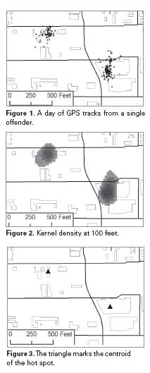
The California Department of Corrections and Rehabilitation (CDCR) has begun tracking more than 6,000 sex offender parolees by using global positioning system (GPS) anklets. Sex offender parolees are allowed to travel only through certain areas and must keep away from other people. The GPS device lets parole agents know when parolees are somewhere they should not be by logging GPS coordinates every minute and sending coordinates to a central server every 10 minutes. This information about parolee location is compared to law enforcement incident data through crime-scene correlation reports. Regular e-mail reports keep analysts notified of any incidents that are close to an offender’s tracks in time and space. The features are accessible through an online mapping application, and analysts can review a parolee’s GPS data for up to 4 hours at a time, or view data in real time (with a 15- minute delay). Keeping track of parolees’ movements can take a lot of time and law enforcement resources. Law enforcement and parole agencies need a way to sum vast amounts of spatial behavior and coordinate it with related crime information. Environmental Systems Research Institute's (ESRI) Modelbuilder and the kernel density tool are essential for analysts who track and analyze sex offender movement data. GPS Monitoring Makes Parolees Accountable for Their Actions Both parolees and officers are accountable for making sure the parolees meet the conditions of parole. Parolees must charge the anklet twice a day, and parole agents must respond to notifications if the parolee enters or leaves an inclusion zone during the prescribed times. Furthermore, the parole agent must keep track of a parolee’s location in relation to new crimes and discuss any possible infractions with the parolee. This keeps the parolee notified that his or her movements are being watched. Although real-time monitoring does not allow law enforcement to apprehend a parolee about to commit a felony, officers must be accountable for post-processing the data and hold an offender accountable for his or her location at all times. Finding a Way to Process the Data When monitoring sex offenders, local law enforcement and regional parole officers need a method to sum enormous amounts of spatial information. Querying 4 hours for a single parolee will yield approximately 240 GPS coordinates, and the server can take up to 15 minutes to process this query. Reviewing a parolee’s movements for a 24-hour period produces 1,440 discrete recorded locations, and most parole agents have a caseload of 20 parolees. The data quickly become overwhelming, and it can be a challenge to determine which locations matter. Agents currently determine which locations to discuss with parolees by using a disciplined process of watching an individual’s movements and inferring behavior. The process of watching an individual’s tracks and recording routine locations or “anchor points” is time intensive. Geographic information systems (GIS) can help automate this process. Each anchor point looks like a cluster of points on a map. GPS point data have time stamps1 that indicate that the cluster covers roughly the same period of time. The cluster’s time stamp also could reveal that the points have left and returned (e.g., when an offender travels between home and work). When analyzing a cluster, the size and GPS drift matter. Analysts should determine how best to discern offender activity and at what distance clusters should remain separate. If the parolee is in the same area for 15 minutes or more, that location needs to be made an anchor point. Using the GIS Kernel Density Tool to Identify Anchor Points The GIS kernel density tool, adapted from ecological studies that tracked animals, is regularly used for hot spot mapping. Crime analysts use the kernel density tool to visualize and define groups of crime, such as hot spots of violent crime. The GPS data are precise and dense enough that the search radius of the kernel density does not need to be as large for crime events. A 100-foot search radius is ideal, and a 20- foot grid cell size supports the small search radius. Tiny “home ranges” are translated to the centroids2 of the hot spot, and these locations become anchor points merged with a larger set of anchor points for that parolee. When loading GPS data into the kernel density tool, analysts should consider time range and amount of data. A time range of 1 to 14 days is possible, and each period produces similar results. Some clusters will be denser, given more time and GPS point data, but the centroid will still be roughly the same. A longer period of time will define more anchor points, but if the analysis process becomes automated and iterative, each new day of data will be incorporated into the ongoing anchor point database. Using ESRI’s Modelbuilder for Anchor Point Analysis ESRI’s Modelbuilder is essential for analyzing sex offender anchor points. Running the model for the anchor point process can take several minutes. The model should be scalable, so that it could potentially be run for all tracked offenders. Once the model has been created, the process is run repeatedly for thousands of tracked offenders and anchor point databases will continue to grow. The geoprocessing steps involved are as follows:
 After the analyst has determined the centroid, the resulting set of anchor point features are merged to the previous set for each parolee. The analyst may wish to use a data-mining procedure to sum the time ranges spent at an anchor point to review offender patterns. This procedure is complicated by the likelihood of the parolee having left and returned to a location. Why Anchor Points Work Anchor points can drive tracking analysis and serve as points of communication between local law enforcement and regional parole offices. When an offender is in the vicinity of a crime, parole agents and crime analysts receive incident hit notification e-mails, which might say, for example, “A parolee tracked by the system is within 1,500 yards and 30 minutes of a time-stamped crime incident.” Most of the correlations will be false, so a parole agent or crime analyst must prioritize which reports are worth investigating. The parole agent can then ask the parolee about specific locations that are a high priority and present results to local law enforcement. Local law enforcement, in turn, can flag specific anchor points about which a parole agent could question assigned offenders. Local law enforcement crime analysts and state corrections programs must work together to monitor sex offenders and ensure that they do not violate parole conditions or recidivate. Law enforcement in California must send incident data involving sex offenders to the CDCR in a timely matter to make crime correlation possible. Furthermore, using GIS to monitor sex offenders is helpful because local law enforcement has a vested interest in understanding and updating the changing local geography. Regional parole offices have a vested interest in monitoring parolee’s spatial behavior, and local law enforcement agencies are interested in keeping their jurisdictions safe. Geographic information systems provide the best possible medium for this type of communication between local law enforcement and regional parole offices. Notes 2A centroid is the center of a polygon. The above was taken from the NIJ's "Quarterly Bulletin of Applied Geography for the Study of Crime & Public Safety" The opinions, findings, conclusions, or recommendations contained in this publication are those of the authors and do not necessarily represent the official position or policies of the U.S Department of Justice. References to specific agencies, companies, products, or services should not be considered an endorsement by the authors or the U.S. Department of Justice. Rather, the references are illustrations to supplement discussion of the issues. |
advertise
|
privacy policy
|
add URL
|
about us
|
terms/disclaimer
|
contact us
|
join our team
|
help

http://www.oncefallen.com/GPS.html In addition to being costly and subject to a myriad of inaccuracy issues, they do not prevent sex crimes from occurring. Its merely another feel good measure.